Thank you to all those who participated in the survey and engagement opportunity. Want to hear what people said? Check out the Engagement Summary and stay tuned for the next steps on this project.
The City of Kelowna is working, with a funding contribution from the BC Ministry of Transportation and Transit, to develop the Preliminary Design for the Clement Avenue Extension from Spall Road to Highway 33.
During the Preliminary Design phase, the project team will:
Advance the design of the Clement Avenue Extension including:
| Consider the wide range of users, interests and infrastructure that exist within the corridor today, including:
|
Provide recommendations to maintain and accommodate the Okanagan Rail Trail Active Transportation Corridor, including identifying:
| Provide an updated scope, schedule and estimate of costs for the Clement Avenue Extension. |
Clement Avenue Extension - Flyover
Learn more about the project by clicking the plus signs below!
Kelowna is one of Canada’s fastest growing communities and is expected to increase in size by 50,000 residents, or 30%, over the next 20 years. As the city grows so will the demand for travel. While transit, cycling and walking will accommodate a growing portion of our community’s trips, driving will remain an important way to move around, particularly for commercial goods. In addition, as the region’s largest employment and services centre, Kelowna attracts thousands of customers, workers and visitors to the city each day. Many of these trips pass through Kelowna's Midtown area.
As a result of Dilworth Mountain and Mission Creek, the city’s road network in Midtown is constrained. Traffic between the east and west sides of the city, as well as regional highway traffic, must use one of three routes: Enterprise Way, Harvey Ave / Highway 97, and Springfield Rd. During peak periods these routes are at capacity.

The Clement Avenue Extension will create a fourth east-west corridor through Midtown, increasing the capacity and redundancy of the road network. This additional route will improve connectivity between Downtown, the North End, Midtown, Rutland and points to the north and east. It will also create future opportunities to consider dedicated transit lanes on Harvey Ave / Highway 97.
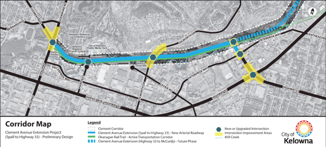
The extension of Clement Avenue, one of the Council’s 2023-26 Priorities, is proposed as a new 2.4km major arterial roadway between Spall Avenue and Highway 33/97. Intersections are proposed at Spall Rd, Dilworth Dr, Enterprise Way and Highway 33/97 and will likely include a mix of traffic signals and roundabouts. To improve corridor capacity and travel times, driveway access will be limited, but access to the City and BC Transit works yards at Hardy St will remain. As the project moves through design, additional information will be used to inform future project phases.

The Okanagan Rail Trail, a regional Active Transportation Corridor, will continue to run adjacent to the new road, although some realignment will be necessary.
The Clement Avenue Extension project has multiple phases. Currently, the section from Spall Rd to Highway 33 is in preliminary design. The next steps for this phase include detailed design, approvals, and construction. The TMP also recommends extending Clement from Highway 33 to McCurdy as a second future phase. Extension to UBC and the airport is envisioned in the long-term.
The Clement Avenue Extension project area, shown in blue below, spans from Spall Road to Highway 33.
- Help more people to reach their destinations in a rapidly growing Kelowna.
- Improve east-west traffic flow through Midtown, including for goods.
- Develop a more resilient road network by adding an additional route linking Downtown to the central and eastern parts of Kelowna.
- Create greater flexibility for the City and Province to consider future dedicated transit lanes on Harvey Avenue / Highway 97.
- Maintain the Okanagan Rail Trail and explore opportunities for improvement, including trail widening, separated space for pedestrians and cyclists, improved street crossings and improved landscaping.
Image 1 of 3


Survey
FAQs
Frequently Asked Questions
The Clement Avenue Extension is a new major arterial road that will help move traffic through the Midtown Area and improve connections across the City. Like other arterials, Clement will be designed to accommodate a range of vehicles, including passenger cars, trucks, commercial vehicles, and buses. Cyclists and pedestrians will be accommodated on the Okanagan Rail Trail.
Starting with the current concept design and informed by ongoing analysis, the corridor is anticipated to be 2-4 lanes wide, with additional lanes at intersections. Both roundabouts with multiple lanes and traffic signals are being considered. The corridor will have lighting, and restrictions on direct driveway access are planned to optimize traffic flow. A mix of natural and formal landscaping is being considered.
Many of the elements of the Clement Avenue Extension are still being determined through the current preliminary design phase and will be further refined through the future detailed design phases. Feedback from this engagement process will inform both.
The Okanagan Rail Trail will continue to function as an important part of the City’s active transportation network. While most of the trail will remain on its current alignment, some portions will need to be shifted to accommodate the new road alignment, challenging topography and intersection layouts. Where the trail is realigned, separate space for pedestrians and cyclists will be considered.
Safe crossings will be developed at intersections, including exploration of grade separation (going under crossing streets) where feasible. Along the trail, pathway lighting will be maintained and opportunities for limiting road noise will be explored. Much of the trail is adjacent to Mill Creek and trail improvements and landscaping will need to consider environmental impacts to the creek’s edge.
As a primary route within city’s active transportation network, maintaining access to the Okanagan Rail Trail is important. However, due to limited space and challenging topography, some closures are likely during construction. A better understanding of construction impacts on the rail trail will not be known until after detailed design. Limiting the duration of closures or providing alternative routing will be considered.
Most construction for the new Clement Avenue Extension will happen away from existing streets. However, improvements to intersections at Clement Ave and Spall Rd, Highway 33 and Enterprise Way, Highway 33 and 97, and a new intersection at Clement Ave and Dilworth Dr will affect traffic flows. A better understanding of construction impact and how they will be addressed will not be known until after detailed design.
While transit service is not planned on the Clement Avenue Extension the City and Regional Transportation Master plans recommend dedicated transit lanes on Harvey Ave / Highway 97 due to their proximity to large amounts of residents, jobs, and services. The Clement Avenue Extension supports this direction by providing an additional route for vehicle traffic through Midtown, creating more flexibility to consider transit improvements on the Harvey Avenue / Highway 97 Corridor. Clement also provides an alternative route for traffic that uses streets where transit operates today, including Enterprise Way (Routes 10, 19), Harvey Ave (Routes 97, 98) and Springfield Rd (Routes 8,9 and 11). Lastly, the project is working to identify space adjacent to Clement Ave that could be considered as an additional transit improvement corridor in the long-term.
Construction of the Clement Avenue Extension, from Spall Rd to Highway 33, is currently included in the City’s 10 Year Capital Plan between 2027-2029. This timeline is a high-level estimate based on the information available from the concept design phase completed last year. Updated timelines will be prepared as part of the current preliminary design phase, and opportunities for timeline acceleration will be explored.
The Ministry of Transportation and Transit has contributed funding for the preliminary design phase of the Clement Avenue Extension. The Clement Extension is a recommended project within the Ministry’s recently adopted Central Okanagan Integrated Transportation Strategy. It is one part of a package of multimodal improvements proposed in the Study to strengthen the region’s transportation systems.
In 2024 a concept design was completed for the Clement Avenue Extension between Spall Rd and Highway 33. This concept aligned with the vision for Clement in the City’s Transportation Master Plan (2021), established an initial alignment for the road, maintained the Okanagan Rail Trail, confirmed the projects viability, and identified challenges that the project would need to address as it advanced.
The concept design also identified space for a potential long-term transit corridor along the route. This phase concluded with a presentation to Council on July 8th, 2024. The concept design forms the starting point of the current preliminary design phase and will evolve as design advances.


